Portfolio

Smart Cities App

member

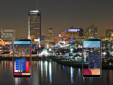
SSTS recently submitted a bid to the city of Long Beach for two separate Smart Cities processes.

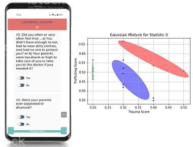
The first was related to the development of an in-field app for police officers to report incidents. The incidents go into a database and are compared with similiar incidents to guide police in their course of actions for their investigations.

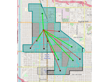
The second was related to the provision of resources for the homeless population. SSTS relied on its geographic and geospatial capabilities to provide an app that guides field workers to give the homeless clients nearby resources for their specific needs.

Despite a final no-bid decision by the city of Long Beach due to Covid-19 pandemic priorities, SSTS has these apps ready to be implemented and expanded upon when the need arises.

Geolocation of Resources

member

It does no good to provide resources to a client in need if those resources are too far away to be accessed.

SSTS has always been involved with the provision of geographically-beneficial resources for clients in need. This might be a resource nearby for a homeless person. Or it might be a geographically-distant resource for a victim of domestic violence or human trafficking.

Regardless, SSTS can present appropriate resources suitable for the recovery of clients in need.

Trauma Scoring App

member

SSTS has developed a multi-survey trauma scoring process that allows first responders and counselors to evaluate the level of trauma present in a client.

SSTS wants to keep intake patients' time as productive as possible. Thus we believe in short and to-the-point surveys. The ACES survey and the standard human trafficking survey fit these beliefs.

By combining these surveys with a Gaussian distribution ellipsoid fit, SSTS is able to generate a reliable score for the risk of a client and is able to guide the necessary resources needed to help the client recover.

Geographic Similarities

member

SSTS recently performed a study to demonstrate the similarities between possible geographically disparate communites and their behaviors.

The study utilized geographic information, demographic information, and voting behaviors along with graph convolutional neural networks to show similiar geographic regions.

This study allowed government officials and private agencies to analogize "what works in community A can also work in community B" to improve the lives of their residents.

Carbon Footprint App

member

As part of a global day of simultaneous Climathons, SSTS representatives joined with others at California State University in Long Beach to develop a Personal Carbon Footprint (PCF) app.

The PCF app allows users to tie their utility bills, driving habits, and other lifestyle habits to APIs from governing agencies and get daily reports and graphs of their own personal carbon footprint.

Armed with a FitBit-like PCA app, users instantly know how their behaviors affect their carbon footprint and can make lifestyle changes to improve the earth's environment and climate - a single person at a time.

Detection of Child Abuse

member

SSTS is a big believer in data collection and in trying to use that data to guide human services and social service workers to make better-informed decisions.

SSTS has teamed with various agencies and hospitals to get a data-driven process in place to help detect child abuse. The process runs in parallel with suspected child abuse cases presented at a hospital's emergency unit.

The process helps guide emergency room doctors and nurses regarding the recognition of child abuse and gives a "second opinion" to those doctors and nurses for their best practice course of action.

Contact

Leave a Message

Contact Us

Social Services Technology Solutions910 Luray Street Long Beach, California 90807 USA


Phone: (562) 548-0509

ray@sotechsol.com

A 501(c)(3) Corporation, EIN 81-1301479